
An Evening on the Divide
AIRGLOW, ISOLATION, AND A MIDNIGHT VIGIL ON THE SPINE OF THE CONTINENT
Part I: The Friction of Departure
Work could not have gone any slower. I sat in my office, watching the digital clock on my computer screen creep toward 4:30 with an agonizing, minute-by-minute deliberation. Every time I looked out the window, the jagged silhouette of the Front Range filled my field of view, a towering reminder of where I wanted to be. The excitement was a physical hum in my chest.
My plan for the night was ambitious, a dream shot I’d been mapping out for months: the summit of Independence Pass, with the core of the Milky Way rising directly behind the iconic Continental Divide sign.
This would be a solo trek in terms of immediate family. Meagan and I had talked it over and agreed it wasn't fair to subject our one-year-old to a night of sleeping in the back of an SUV at timberline. But I wouldn’t be entirely alone; Meagan’s cousin, Mark, had been itching for a camping trip for a while and confirmed he was available to meet me up there for an overnight campout.
When the clock finally struck quitting time, the administrative world vanished. The race was on.
I rushed home through the initial wave of traffic, my mind already calculating exposure times and fuel stops. Meagan was a saint: she had already prepped a bag of snacks, Uncrustables, and drinks, meaning my transition from office worker to mountain nomad took less than fifteen minutes. I threw my camera packs, heavy tripods, and cold-weather sleeping supplies into the back, called Mark to confirm he was on his way from his end, and hit the road.
I knew cell service would disintegrate the moment I neared the Sawatch Range, so I gave him simple instructions: “I’ll be at the top of the pass. Meet me at the summit overlook.”
Then, I hit the brick wall that is Colorado Springs infrastructure.


If you’ve ever tried to leave the Springs on a Friday evening during rush hour, you know the specific brand of frustration it breeds. There is no true east-west thoroughfare in this city. You are forced to navigate an agonizing gauntlet of traffic lights, concrete expansion joints, and local commuters just to reach Manitou Springs and the mouth of U.S. 24. The mountains look close enough to touch, yet forty-five minutes of my precious daylight were spent burning fuel at idle and watching brake lights flash in a hot summer haze. Impatience crept in, that pesky, unwelcome passenger. The sky overhead was choked with a thick layer of gray clouds, but my obsessive weather checks promised a clearing trend by 9:00. I had to trust the data.
The bottleneck didn't ease as the elevation climbed. The road narrowed into Ute Pass, carrying thousands of weekend warriors with the exact same idea: escape the pavement. By the time I crawled into Woodland Park, the traffic was a solid, slow-moving serpent. I had initially planned to pull into a drive-thru for a quick, hot meal - the last standard fast-food option on the route - but the lanes were so jammed I couldn't even maneuver to turn off.
I made a split-second decision to push through. I reached into the passenger seat, ripped open an Uncrustable, and chewed while listening to Wagner’s opera Lohengrin while keeping my eyes glued to the bumper ahead (for those who don’t know, I’m kind of a music snob).
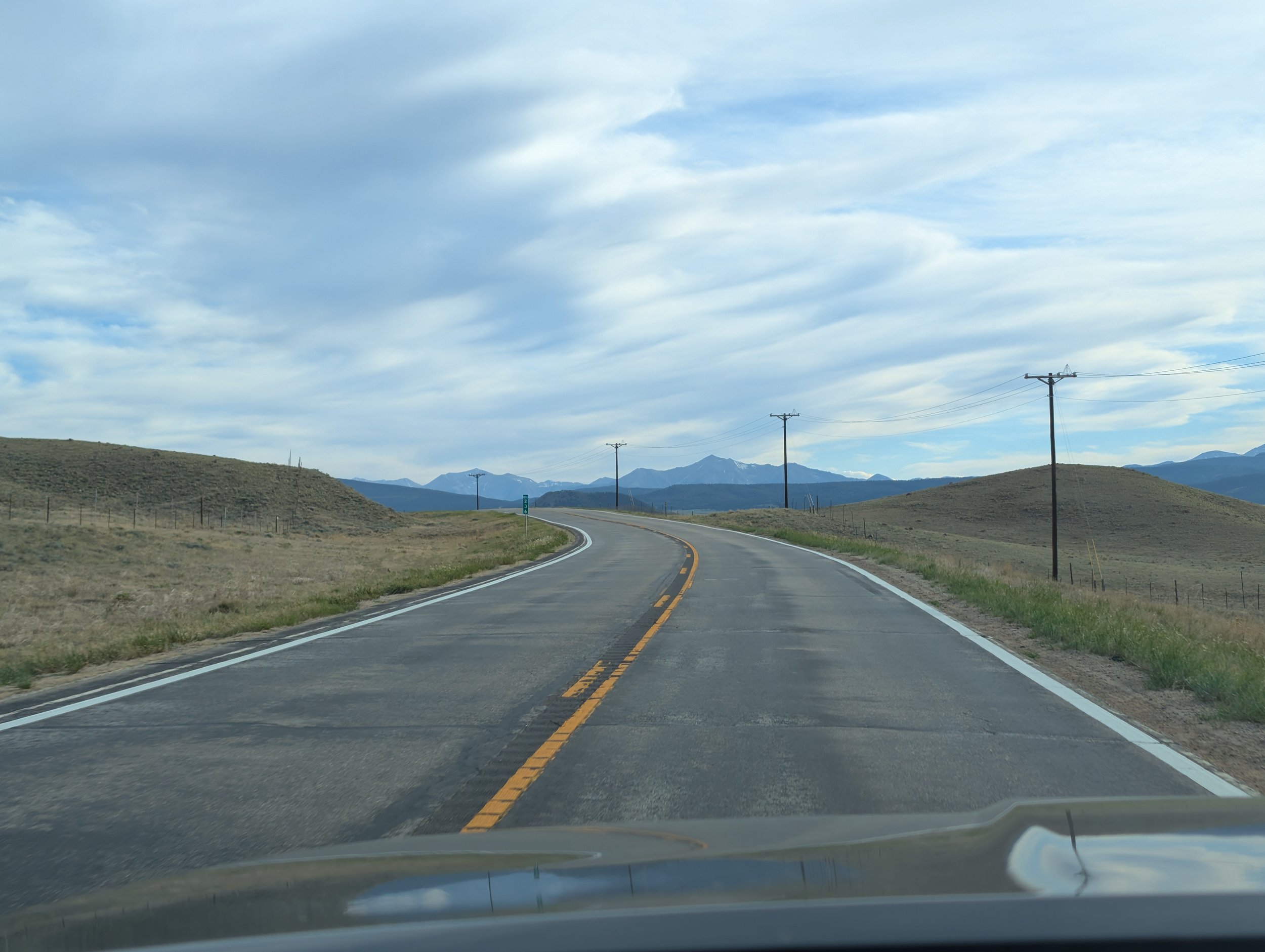
Past Woodland Park and Divide, U.S. 24 drops into a winding, two-lane country mountain road. Here, the real test of patience began. I found myself trapped in a caravan behind a three out-of-state sedans moving a full ten miles per hour below the speed limit. With oncoming traffic steady and double-yellow lines painting the asphalt, there was nothing to do but watch the clock tick away.
It wasn't until I cleared the crest of Wilkerson Pass and descended into the massive, high-altitude bowl of South Park that the landscape finally opened up. The road split into passing zones. I stepped on the gas, and along with a few other frustrated drivers, swept past the rolling roadblocks into the open basin.
PART II: The Open Basin & The Historic Core
The relief of the open road is a palpable thing. Near the tiny junction of Hartsel, the bulk of the tourist traffic split north toward Fairplay and Breckenridge, leaving the southern stretch of asphalt blissfully vacant. For miles, it was just me, the steady hum of my tires, and the immense, sage-brushed expanse of the high plain. To the north, the heavy cloud deck was fracturing, revealing slivers of pale blue sky. If those clouds lingered just long enough to catch the setting sun, I knew I’d be treated to an unbelievable show.
I drove past herds of pronghorn grazing in the valleys and distant bison moving like dark boulders across the landscape. By the time I bypassed Buena Vista, the temptation to stop at a sit-down restaurant flared up. The mountain town was alive with the glow of patio lights and the smell of woodsmoke, but I didn't have the luxury of time. The night required efficiency. I chose the mountain over the meal and continued north towards the tiny hamlet of Twin Lakes before heading straight for the base of the mountains.
I rolled into Twin Lakes around 7:45, and every ounce of lingering road frustration dissolved.
Field Notes: The Gateway at Twin Lakes
Nestled at the foot of Independence Pass, Twin Lakes feels like a living remnant of the late 1800s. Originally established as a way station for miners traveling between Leadville and Aspen, this quiet settlement boasts a year-round population that barely clears double digits. It sits under the literal shadow of Mt. Elbert - the highest peak in Colorado and the entire Rocky Mountain chain - which rises to a staggering 14,440 feet. Because of its massive eastern bulk, the mountain casts the historic town into a deep, cool twilight long before the sun actually sets below the western horizon.
Near the edge of the lakes stands a weathered, historic log barn flanked by a small, still pond. The jagged, snow-dusted peaks of the Rockies rise directly behind it like a wall of granite and ice. I pulled off the shoulder, grabbed my camera body and lens, and walked down a faint game trail through the high grass toward the water's edge.
To my amazement, the pond was a flawless mirror. The wind had died completely.
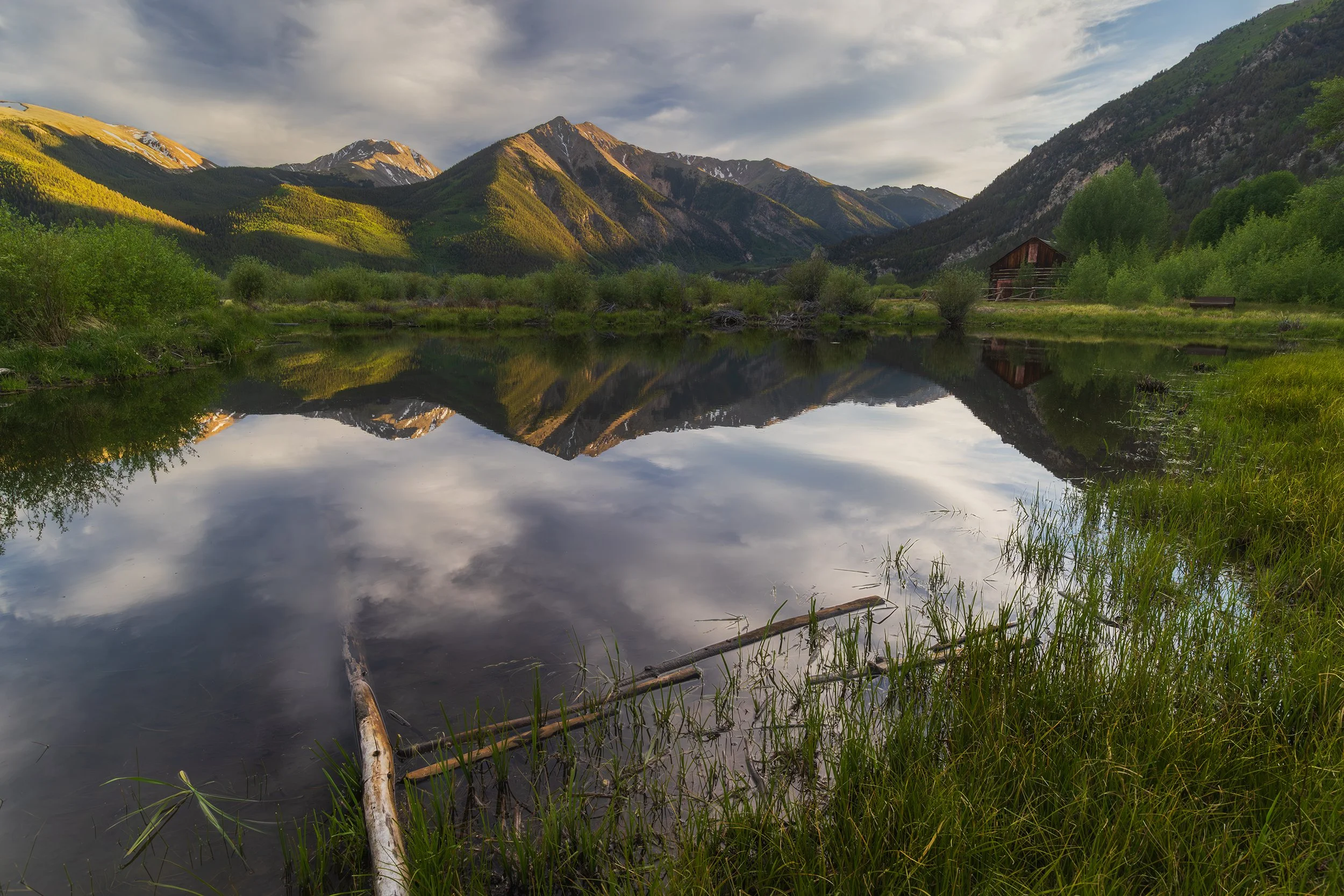
An Evening at Twin Lakes, 20mm | 1/60 sec., f/14, ISO 800

As I leveled my tripod, the sensory detail of the Colorado mountain landscape washed over me. Birds were singing their final evening notes, darting overhead. A light, cool breeze occasionally rustled the long alpine grasses. In the distance, the faint, warm sound of laughter and clinking glasses drifted over from the historic village. The very last rays of daylight were striking the high ridges of the continental divide, painting the stone in a rich, copper glow.
This, I thought to myself, is exactly what summer in Colorado is meant to be. I triggered the shutter, capturing the quiet endurance of the old west preserved at the foot of the giants.
Part III: Up the Spine of the Continent
With roughly thirty minutes left before the sun dipped completely, I packed my equipment into the car and surged up the eastern switchbacks of Independence Pass. I expected a chaotic scramble for parking or a line of cars on the narrow shelves, but the road was completely empty. The campgrounds scattered along the lower reaches of Lake Creek were full to capacity - each displaying prominent "Be Bear Aware" warnings on at the entrances - but the pavement itself was a solitary ribbon. I passed a large bulldozer on one of the hairpin turns, and the stakes alongside the road began to rise taller and taller.
I reached the summit parking lot just as the sky began to bleed orange. A small handful of travelers were gathered in the parking area, bundled against the sudden drop in temperature. I hoisted my heavy camera pack, grabbed my carbon-fiber tripod, and broke into a jog up the paved summit trail.
Let me tell you: running at 12,095 feet is a violent reality check for your lungs.
Elevation Profile
The Ascent to Independence Pass
| Location | Elevation | Atmospheric Notes |
|---|---|---|
| Colorado Springs | 6,035 ft | Baseline environment - Hot, overcast summer afternoon |
| Twin Lakes Base | 9,200 ft | Twilight setting, cool valley air |
| Independence Pass Summit | 12,095 ft | 35°F, alpine tundra, thin air (40% less oxygen) |
Within fifty yards, my chest was heaving and my throat burning from the thin, crisp air. But as I stopped to catch my breath at the top of the overlook, a profound sense of joy completely eclipsed the physical strain. I stood on one of the highest paved mountain passes in North America.
Originally an old toll road carved through the mountains during the silver boom, this narrow stretch of Highway 82 is a seasonal wonder, closed entirely all winter under tens of feet of snow and only recently cleared by heavy bulldozers for the brief summer window. It serves as a stark, wild gateway to the Hunter-Fryingpan Wilderness, a place where human engineering stops and the raw, unyielding elements of the alpine tundra take over.
Standing there, looking out over the endless waves of peaks of the Rockies, a single thought repeated in my mind: I love where I live.
I felt an overwhelming wave of gratitude - for the health and physical stamina to run around at twelve thousand feet, for the means to drive just a few hours from my front door to witness what felt the edge of the world, and for the timing that placed me here for this specific sunset.
The summits were caught in a fiery, deep crimson light, and the remnant clouds from the afternoon storm had transformed into brilliant pink mares' tails across the sky. I moved off the paved path carefully, stepping only on solid rock to ensure I didn't crush the fragile, slow-growing alpine flora that takes decades to recover from a single careless footprint.
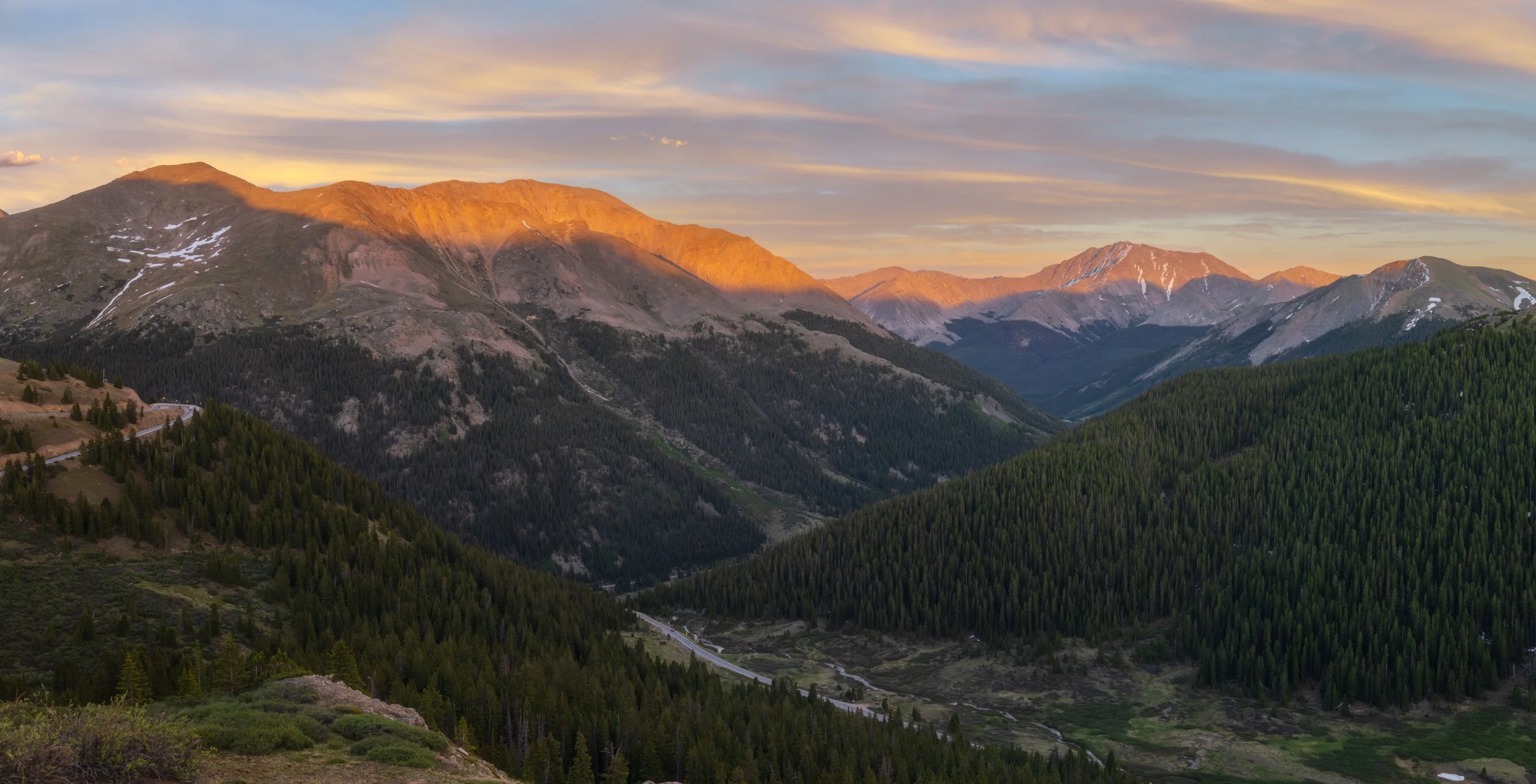
Last Light on the Sawatch Range, Panorama, 35mm | 1/30 sec., f/11, ISO 800


As the color drained from the peaks and the blue hour took hold, I walked back toward the main overlook and met a family from Ohio. Along with another solo traveler, they had noticed me sprinting up the trail with professional gear and asked if they could see a sneak peek on the back of my camera LCD. When I showed them the raw sunset frames, their eyes went wide. We stood there chatting in the darkening cold; they were on a massive road trip heading out toward Zion National Park in Utah, and I happily gave them a list of my favorite off-the-beaten-path locations within the park.
They mentioned they were staying at the pass to see the Milky Way, which brought a crucial realization to mind. For those who grow up in the East, a true night sky is a rare, almost extinct commodity.
The Vanishing Dark
Due to urban sprawl and light pollution, a vast majority of the global population lives under a perpetual, artificial gray twilight. This light pollution doesn't just block our view of the cosmos; it actively disrupts migratory bird patterns, throws off ecosystem dynamics, and severs a primal human connection to the stars. High-altitude summits like Independence Pass act as vital nocturnal refuges. Shielded by altitude and isolated by wilderness boundaries, these alpine crests remain almost entirely devoid of stray artificial light, allowing the universe to show itself in its raw, unfiltered glory.
PART IV: The STrategy and Silence
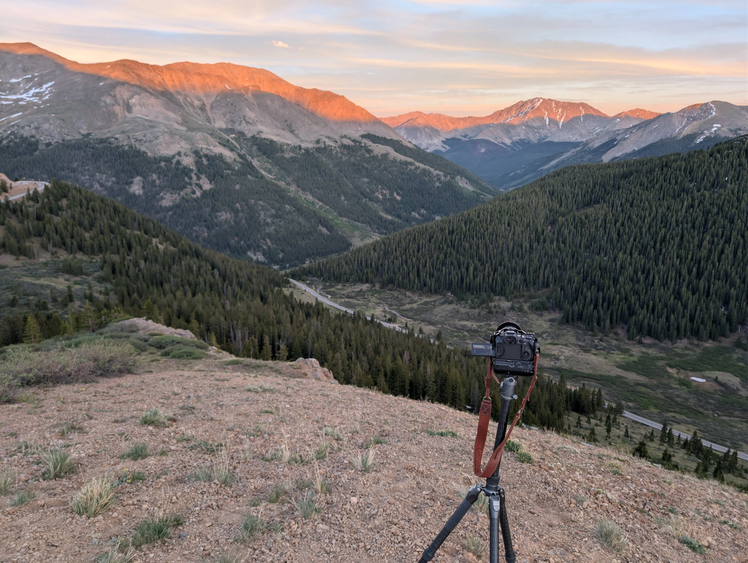
With the darkness deepening, I set to work on the technical foundation of the image. I used the PhotoPills app on my phone, employing the augmented reality live-view mode to track the exact trajectory of the galactic core. I needed to see precisely where the densest part of the Milky Way would intersect with the horizon line in relation to the mountains and the Continental Divide sign.
To achieve a clean, professional-grade astro-landscape image, you cannot rely on a single exposure. High ISO settings introduce digital noise that destroys detail in the landscape. My strategy was to capture clean, sharp, low-noise "blue hour" foreground images right now, using a low ISO and a long shutter speed while there was still a tiny amount of ambient light in the sky. Later that night, I would shoot the tracked star exposures and blend the two layers in post-processing.
Once I locked in the foreground frames, I walked back through the freezing darkness to my SUV. The temperature was plunging rapidly toward the predicted low of 35°F. I used the remaining hour before true night to organize the interior of the vehicle and build my sleeping arrangement.

I laid down a protective bottom blanket layer, inflated my Klymit sleeping pad, and unrolled a heavy down comforter designed for sub-freezing alpine conditions. I climbed in, tested the clearance for my shoulders, and satisfied with the warmth, lay back to wait.
Up here, there is no cell service. No bars, no data, no notifications.
Honestly, it was an incredible relief. For a solid hour, I sat in the stillness of the vehicle without the ability to compulsively check my phone. There were no incoming emails, no texts to answer, and no infinite scrolling through social media algorithms. It was just me, the immense weight of the surrounding mountains, the first stars puncturing the velvet sky, and the steady, low moan of the wind buffeting the chassis.
There is a rare comfort in that kind of isolation - a deep peace found only in the remaining remote, rugged corners of the world where modern connectivity cannot reach.
However, the lack of service meant I was completely blind regarding Mark's status. I had to trust that he had followed my directions and was making his way up the mountain. Every time a pair of distant headlights materialized on the lower switchbacks, tracing a slow, glowing path up the pass, I leaned against the glass and wondered if it was his truck, each time disappointed as the headlights blurred past and continued towards Aspen. Undeterred by the solitude, I watched the night sky slowly transform the ancient stone landscape outside.
After checking my watch and realizing it was already 10:25, it was go time.
Part V: Chasing the Airglow
The moment I stepped out of the vehicle, the freezing mountain air hit my lungs like a physical shock. In the span of an hour, the complete absence of solar warmth had plunged the temperature on the summit. I pulled my jacket tight, zipped it to my chin, and stepped off into the dark.
A steady breeze was sweeping across the pass, but I managed to find a tactical setup location directly behind a small wooden utility building near the overlook, using the wall as a shield from the wind. I switched my headlamp to its red-light mode to prevent my pupils from constricting (and thereby preserving my adjusted night vision), and began assembling the complex components of my star-tracking rig.
Within a few minutes, the gear was assembled and wired. I powered on my Benro Polaris star tracker, syncing it to my phone’s GPS to calibrate its exact coordinates.
One of the most remarkable features of modern smart trackers is that you no longer need a clear, unobstructed view of Polaris (the North Star) to achieve perfect polar alignment. Because a mountain blocked my view of the north, I utilized the tracker's "go-to" feature and targeted Antares - the brilliant, fiery-red supergiant shining brightly in the southern sky a few 550 light-years from Earth. After a few micro-adjustments to the motorized axes, the unit calibrated its position against the rotation of the Earth. I switched my lens to manual focus, magnified a bright star on the camera's live-view screen until it was a perfectly sharp, pinpoint pixel, and locked down the focus ring. We were all ready to begin.
I set the exposure for a two-minute test shot. The shutter clicked open, and the tracking head began its imperceptible, ultra-precise rotation, perfectly counteracting the spin of the globe.
When the two minutes passed and the shutter snapped shut, I looked at the rear LCD screen and felt my jaw drop.
The Milky Way was spectacularly prominent, its dark dust lanes cutting through the dense stellar fog of the galactic core with incredible clarity. But the true masterpiece of the frame was something I hadn't anticipated: a massive display of atmospheric airglow.
Astro-Physics Fact Check: Airglow vs. Aurora
While it looks strikingly similar to the Northern Lights on a camera sensor, airglow is an entirely different atmospheric phenomenon. Auroras are caused by high-energy solar winds colliding with Earth's magnetic field, steering charged particles into the polar regions. Airglow, however, is a permanent planetary phenomenon caused by chemiluminescence. During the day, intense ultraviolet sunlight ionizes the molecules in the upper atmosphere. At night, these atoms slowly recombine, releasing their stored energy in faint, colored wavelengths - typically green from oxygen atoms and purple or red from hydroxyl molecules. It is incredibly faint to the naked eye, but a long exposure reveals it as luminous, cosmic ribbons rolling across the sky.
The sight of those green and purple bands rippling through the stars sent a massive spike of adrenaline through my veins, completely obliterating the cold. I spent the next two hours experimenting, pushing the exposures to three and five minutes, adjusting the ISO to find the absolute sweet spot between dynamic range and sensor heat noise. Nearby, I set up my Insta360 action camera to capture a continuous time-lapse of the galactic core rising over the pass. Because of the long interval times, the ninety minutes of real-world shooting translated into just four seconds of finished video file - but those four seconds captured a breathtaking cosmic dance.
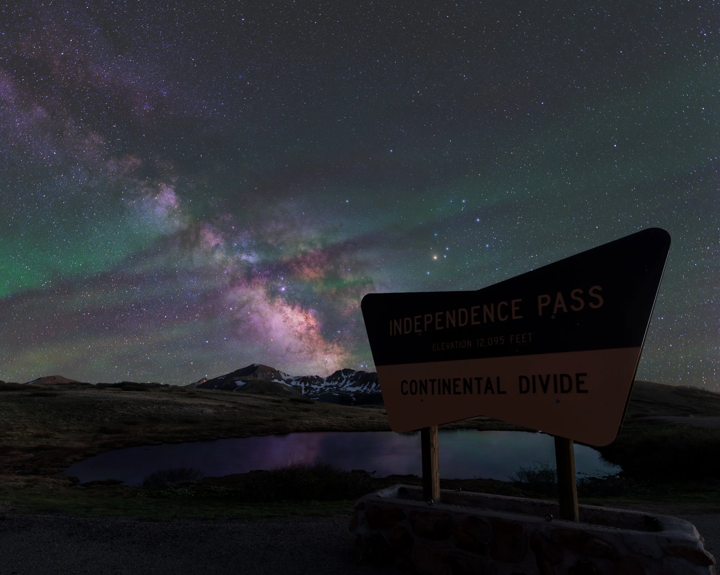
Midnight on the Divide, 19mm | Star Image: 167 sec., f/4, ISO 1600 - Foreground Image: 5 sec., f/10, ISO 1600
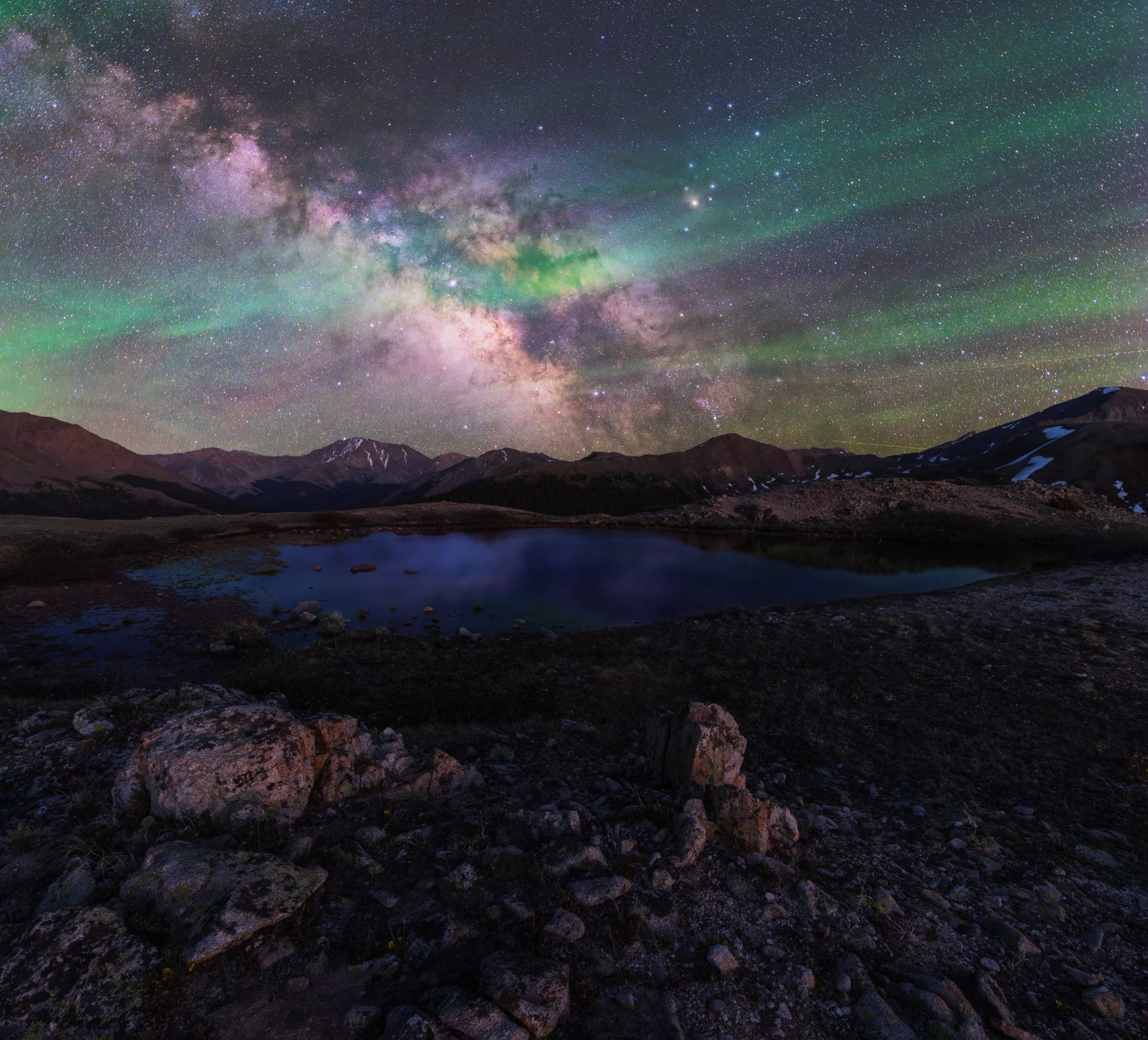
Colorado Dreams, 17mm | Star Image: 151.8 sec., f/4, ISO 1600 - Foreground Image: 1.3 sec., f/14, ISO 800
By 12:30 AM, there was still no sign of Mark. My fingers were stiff, and after more than two consecutive hours of shooting, I knew I had collected enough raw data to process at least one image. I carefully packed the frozen cables, tripods, and tracker into the vehicle, whispered a quiet expression of thanks to the silent summit of the pass, and began the slow descent back down the pass.
At that hour, I was almost certainly the only human being awake on Highway 82.
The darkness at twelve thousand feet has a heavy, velvet quality that seems to swallow light entirely. Even with my high beams slicing through the clear air, the illumination only pierced a short distance ahead, beyond which lay the sheer, unguarded drop-offs I had noted during the daylight drive. I kept my speed low, my foot hovering over the brake.
Suddenly, a pair of glowing eyes materialized in the beams - a red fox darted across the blacktop, followed a mile later by a cautious buck. They were quiet reminders that these roads belong to the wild things long after the tourists go to bed.
I rolled back into the empty valley of Twin Lakes, where my phone suddenly found a single bar of cellular service. A string of delayed notifications flooded the screen. I pulled over and scanned the messages from Mark. There was only one text, sent hours prior: “Where are we camping tonight?”
I stared at the screen. “Well,” I thought, “that’s not exactly helpful.”
With no way to pinpoint his location in the dark, I drove on, until I found a sign for camping near the lakes of Twin Lakes. A followed the secondary, dirt road for about a mile until the shadowy profiles of conversion vans and overland rigs parked along the perimeter came into view. I pulled into a vacant spot, cut the engine, extinguished the lights, and climbed into the back setup.
Outside, the wind was howling through the valley trees and across the lake, shaking the frame of the SUV. The ambient temperature inside the cabin was hovering somewhere in the low 30s, but wrapped securely inside the down comforter and insulated by the Klymit pad, I was incredibly warm and cozy. I closed my eyes, drifting off to sleep with the image of green cosmic airglow burned into my retinas.
PART VI: First Light and a Missed Connection
My alarm rang out into the dark cabin at 5:00 AM.
The air inside the vehicle was freezing, turning my breath into thick plumes of vapor. Through the frosted windows, I could see the very first, faint line of deep blue and violet beginning to bleed into the eastern sky. I dragged myself out of the warmth of the sleeping situation, checked my phone, and found a text from Meagan. She had managed to get a location drop from Mark before his signal dropped out completely: he was parked just ten minutes away at the Mt. Elbert Forebay access area.
Damn, I thought, a wry smile hitting my face.
It was a perfect reflection of the reality of mountain travel. In these high-altitude environments, you have to be completely self-sufficient. You cannot rely on modern communication or expect plans to unfold with urban precision. The mountains demand flexibility.
I climbed into the driver's seat, cranked the engine, and turned on the defroster. I pulled out of the dirt lot, my headlights cutting through the fine dust kicked up by the relentless mountain wind. The roads were completely barren as I backtracked to the historic core of Twin Lakes.
My goal was to capture the exact same composition from the evening before - the old log barn and the pond - but this time with the first rays of morning sunlight hitting the face of the Sawatch Range.
I set up my tripod in the bitter morning chill, my hands stinging as I waited for the sun to clear the horizon behind me. As the light grew, a lone beaver emerged from the edge of the pond, swimming back and forth across the glass-like surface with mouthfuls of grasses and twigs for a nearby dam.
Fortunately, his wake didn't disrupt the center of the pool, leaving the mountain reflection intact. The sun finally broke, casting the high peaks into a brilliant, fiery orange-gold that burned against the cool blue of the western sky.
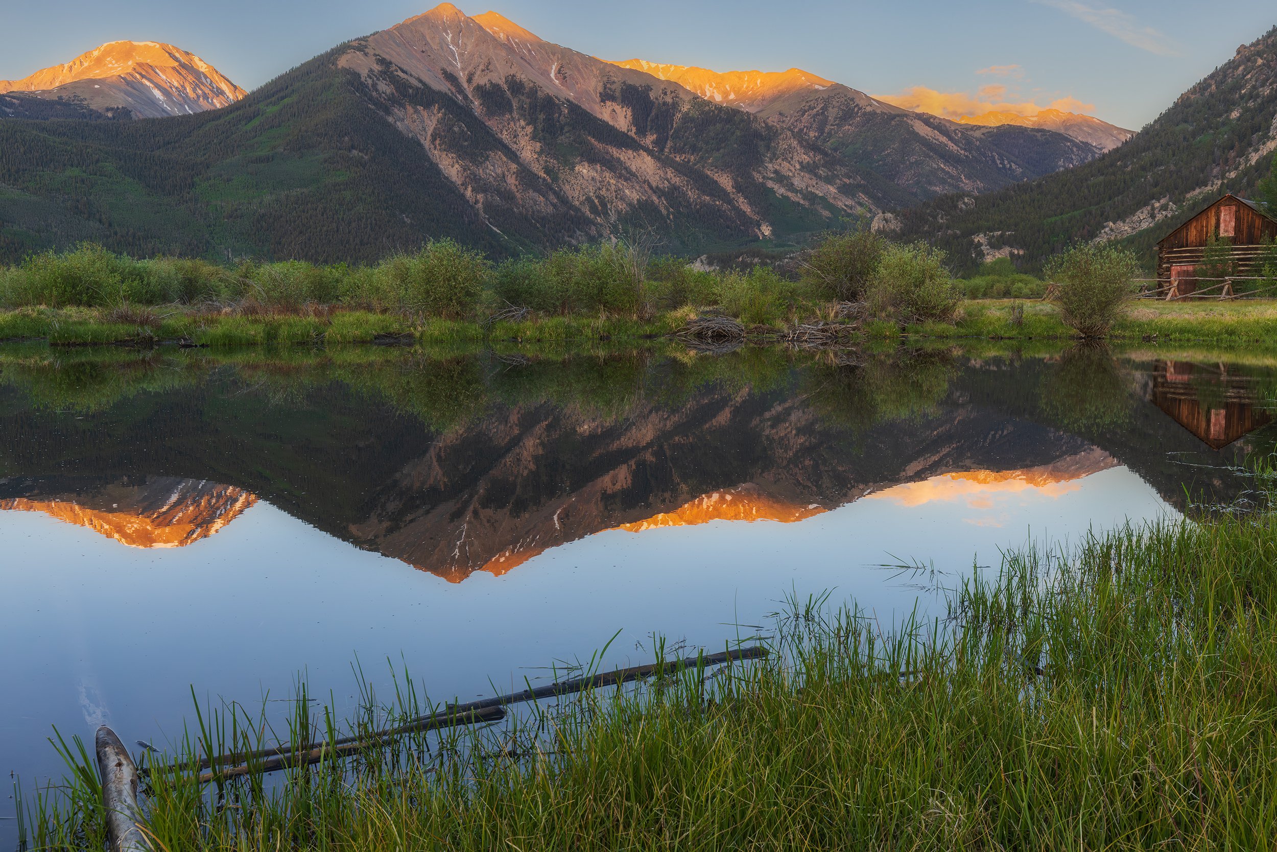
Rustic Sunrise, 35mm | 1/25 sec., f/14, ISO 800
With the sunrise frames secured, I drove back up the lower switchbacks of the pass, looking for unique perspectives I had missed in my rush the night before. I passed the trailhead for La Plata Peak, which was already choked with vehicles; dozens of hikers were likely already high on the ridges, racing to summit the fifth-highest peak in the state before afternoon lightning storms rolled in.
I turned off near a small clearing where Lake Creek cuts through the valley floor. Standing by the rushing water, surrounded by the scent of damp pine needles and cold stone, I launched my drone into the crisp air.
I flew the aircraft up the valley, capturing a unique top-down perspective of the braided creek carving its way through the glacial valley, its winding channels still in shadow while the snowcapped peaks caught the first morning light, towering in the background. The sheer beauty of the scene was overwhelming.
The biting chill, the clean smell of the wilderness, the roar of the water - it all makes you feel intensely, vividly alive.
After landing the drone and packing the gear, I set out to track down Mark. I turned onto the rough, washboard gravel of the Mt. Elbert Forebay access road, passing dozens of dispersed campers sleeping in tents and rigged-out trucks. A few miles up the steep track, I spotted his familiar truck sitting in a dirt pullout.
From his specific vantage point on the ridge, you could actually look across the valley and almost see the exact clearing where I had spent the night.
The sun was high now, warming the landscape. I walked over, knocked on his window, and woke him up. We stood out in the mountain air for twenty minutes, laughing about the complete absurdity of our missed connection. He explained that by the time he had reached the lower switchbacks of the pass the night before, exhaustion had completely overtaken him; he knew he couldn't safely navigate the high cliffs in the dark while sleep-deprived, so he turned back and found the first available campsite he could find.
It was a short, classic mountain reunion. After catching up, it was time to point the vehicle back east. I stopped for fuel in Buena Vista, cracked open an energy drink, and retraced my route through South Park and down U.S. 24. Because it was still relatively early on a Saturday morning, the incoming tourist traffic hadn't hit its peak yet. I rolled into my driveway in Colorado Springs just before 10:00, with an entire weekend still ahead of me, and a memory card full of ancient stellar light.
PART VII: Reflections on a Transience Landscape
Looking back on this wild overnight trek, I am filled with an immense, lasting sense of gratitude for these raw moments in the wilderness. It is easy to get caught up in the modern routine of office walls, city traffic, and digital notifications. But experiencing the true, unfiltered beauty of the physical world - standing under a night sky illuminated by planetary airglow and ancient starlight - reminds us of our true place in the ecosystem.
I will always advocate for people to step away from the convenience of modern culture, to pack a bag, hit the road, and explore these rugged, unexpected places. It is the only way to keep our connection to the land alive.
This specific trip, however, carried a bittersweet weight. I love where I live. Colorado has been a profound sanctuary for my photography and my soul over the last two years. But change is an inherent part of a military life. In a short time, I will be PCS-ing to California.
While I am incredibly excited for the new adventures that await along the Pacific coast, such as the jagged sea cliffs, the towering Sierras, and the vast desert wilderness areas I have yet to explore, leaving this rugged Rocky Mountain landscape is a heavy thing. These peaks, these freezing midnight passes, and these quiet valleys have shaped my vision as an artist and an advocate for the land.
California represents a beautiful new horizon, but Colorado will always hold a permanent, unyielding piece of my heart.
If you want to follow the journey behind the lens and receive deep, unfiltered field dispatches, gear breakdowns, and regional mapping guides directly from the backcountry, consider joining our community below!